Monday Bridges and BIrds
Double-click on any image to view it full size. Click the back-button to return to your place on this page.
Greetings!
Our most recent trip to Topsail Island provided the thought for – and some of the pictures in – this week’s essay.
Like many of North Carolina’s barrier islands, Topsail Island was basically deserted before World War 2, and accessible only by boat. Then the military arrived. Topsail Island was a perfect location for a missile testing range (long since abandoned), and in due course a pontoon bridge was built. However, as non-military use of the island grew, the pontoon bridge was inadequate, besides which it impeded the growing recreational boat traffic along the Intra Coastal Waterway, and in November 1955 a new swing bridge was built at approximately the mid-point of the island. This swing bridge has remained in operation ever since, opening as often as once every hour.
Picture #1
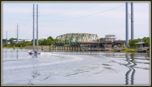
shows a general view of the bridge, and was taken during our trip last week from Soundside Park, which is on the island, with the mainland being in the background on the left hand side of the image. Image #2
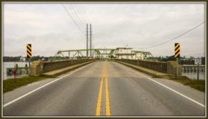
is the view you do not want to see if you are trying to drive off the island! An even worse situation would be if you were trying to drive a fire engine onto the island! #3 shows just such a vehicle on the bridge,
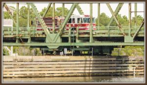
although the main purpose of this picture is to show the central pivot point of the bridge structure with its “lazy susan” arrangement of supporting wheels running around a circular track. (We do have some fire trucks based on the island.) The bridge pivot support structure divides the waterway into two parallel channels. Picture #4 shows four northbound pleasure craft passing through the east channel.
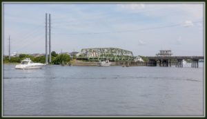
(A modified version of this image forms the header image on this website.) Even though there is now another bridge linking the island to the mainland further north, the swing bridge is the most heavily used, and especially during the summer vacation season, traffic backs-up badly when the bridge opens. Furthermore, the bridge is now over sixty years old, and, while still safe within its design limits, the North Carolina Department of Transportation classifies it as a “structurally deficient bridge”. Therefore a brand new high-clearance (sixty five feet) fixed bridge is now being constructed just south of the swing bridge, which will be decommissioned once the new bridge is completed. Picture #5 shows the beginnings of the new bridge.
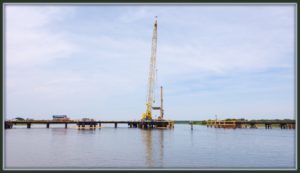
This picture was taken from basically the same spot as #4, but looking roughly south instead of roughly north. During construction boat traffic will pass through the gap just to the right of center. Almost all the visible structure is for temporary use, and will be removed once the new bridge is complete. Sitting apparently in the middle of the gap, but actually on “this” side of the channel, is a wooden navigational marker. Zooming-in on this marker (literally – I only had my 28-300mm lens with me on this trip) we finally get to the birds referred to in the title, because a pair of ospreys have built their nest on this marker (image #6),
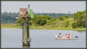
right in the middle of the noise and commotion of the construction! I think the people in the boat are actually looking at the construction work rather than the osprey, which may be very difficult to spot from water level unless you know it is there. I have seen ospreys nesting on other navigation markers in the general vicinity in previous years, but I had not expected them to return this year simply because of all the disturbance, and so was thrilled to see this nest! But even better than just seeing the nest was seeing that there are (at least) two chicks in the nest! #7 is digitally cropped and zoomed as far as I can push it (even with the new camera), so it is not a great picture technically, but it clearly shows the adult spreading its wings while the two chicks sit up and look around under the parent’s right wing.
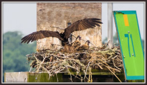
In the original image their yellow/orange eyes are visible. I waited for more than an hour in the hope that the other parent would bring a meal for the family, but no such luck this time.
Picture #8 also shows an Osprey, and was taken in the exact same location as #7 just a few minutes later, but this is a V-22 Osprey tilt-rotor aircraft belonging to the Marines.
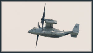
Examination of its markings show it belongs to VMM-263 “The Thunder Chickens”, currently based a few mile north at Marine Corps Naval Air Station New River, which is part of the Camp Lejeune Marine complex in Jacksonville, NC. VMM-263 was the first squadron to become operational with the Osprey.
Image #9 shows a pair of (avian) ospreys at their nest on the edge of the Camp Lejeune complex a couple of years ago.
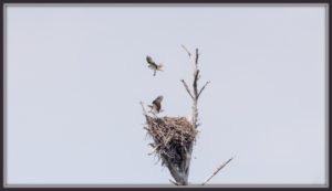
This nest was quite close to the bridge shown in #10.
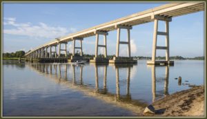
This bridge is not actually on Topsail Island; rather it crosses the New River Inlet. The highway it carries runs from Snead’s Ferry (left background) to the Camp Lejeune “back gate”. Until just a few years ago, the general public could then drive through Camp Lejeune and thence to Swansboro and Emerald Isle, but security concerns caused the road through the camp to be closed to the public, and general access now ends at the nature area from which #9 and #10 were taken.
The bridge in #10 is virtually a carbon copy of the bridge shown in #11, which is the newer Topsail Island bridge, mentioned earlier in this essay. The mainland is in the background.
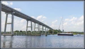
This is the bridge we normally use on our “commute” to Topsail. Barely visible in this picture is the marker board which shows the available clearance under the bridge, which varies somewhat depending on the state of the tide, but is nominally sixty-five feet – the same figure that will be achieved by the new bridge. The young lady sitting on the bow of the boat in this picture watched very carefully as they processed very slowly under the bridge!
To the left (south) of the bridge in #11, you can see a set of very tall steel pylons which carry a main electrical power line onto the island. This week’s final picture, #12, shows a Bald Eagle sitting on top of one of those pylons.
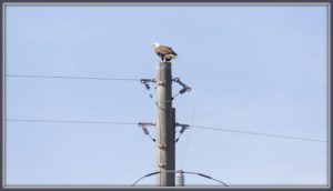
This picture is one of a set I took in March last year. We saw the bird while driving over the bridge, and having taken a couple of shots as we drove past, we then parked on the mainland side of the bridge and I then walked back up the bridge for a better view. I had never realized until then how low the side-rails of the bridge are, and how vulnerable one feels, especially when you get to be about sixty feet up!
I normally try to close these essays with one of the best images. This week I am breaking that habit partly to suit the flow of the story, but also, since the Bald Eagle is one of our national symbols, to celebrate, albeit a couple of days early, Independence Day!
Have a great week, and especially a great Fourth of July!